
From this chapter, you will learn methods of analyzing a piece of land for development, the methods in conducting feasibility study and how to ascertain a good return on investment.
Before we begin, let’s first look at a typical project life cycle in the world of property development. Every step in the cycle is just as crucial to the viability of the project. The steps in the project life cycle are:

Feasibility study kick starts the project as the first and most important step. This is where lands are evaluated based on the size, numbers, price, location, type and the various surrounding factors. It is at this very step where we determine if the land is worth exploring. Considering there are so many factors that can contribute to the success and failure of a project, how do we then conduct a feasibility that is effective? What are the practical ways to study a piece of land? How much is not too much to study since over analysis leads to paralysis?
In my learning years and right up to my development exprience, I have come across quite a few feasibility study methods being used by different people and companies. Every model has its own strengths. Sometimes it is also due to familiarity. They however share a common ground and I’ve compiled them here as my personal 10 Level Feasibility Study Framework. I have used this method in all my projects successfully and they have proven to be effective. The 10 Levels are :

LEVEL 1 Rule of thumb
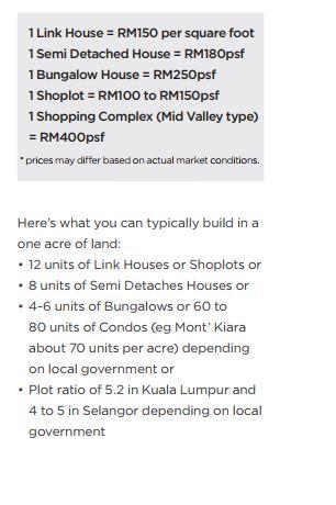
The Rule of Thumb level helps you to quickly identify the cost or numbers related to a particular type of development given a particular type of land. In other words, you will be able to immediately conclude if Land A is worth building a row of link houses even without stepping on site. The basis is to firstly understand this formula:

LEVEL 2 Basic data study
At this level, we will be studying the map where the subject land is located, its topography, population demographics and its surroundings characteristics to achieve a basic estimation for the feasibility. In other words, if an agent or land owner comes to offer you a land, what documents do you require? Here’s the checklist.

For a sample of conducting Basic Data Study, please refer to the Kajang case study in Chapter 4.
LEVEL 3 Site visit
Not every land requires a site visit at the beginning stage. Those with poor numbers or data to show from the first two levels can easily be disqualified. To have come this far, you’ll be setting your eyes on the physical environment of the subject land.
Your primary aim when at the site is to ascertain if what you have compiled in your basic data matches with what you see. Here are some of the things you should be looking out for when visiting on site:

Let’s take a look at each item a little closer.
a. Accessibility
i. Existing Access
Having a good understanding of the traffic flow will enable a better analysis of the subject land.
ii. Legal/Permanent Access
This points to the actual permissible and legal access as provided by the Planning Department and the Land Office. From here, you will be able to see things such as the government road reserve.
iii. Construction Access
We need to identify where the construction vehicles will be coming in from. We also need to ensure their exit paths are not dangerous e.g. children playing nearby increases the risks of accidents.
iv. Showroom Access
This is an important access because this is where the clients make their way in to buy the properties. As such, it is important to have a direct access where the showroom will be well exposed to the public’s eyes.
v. Future Access
We also need to identify if there are new access in the plans by the government. This is important because a good access will give appreciation to the land value. For example LDP (Lebuhraya Damansara Puchong) made Puchong highly accessible and in turn boosted its property value, MEX (Maju Expressway) provided a good access to Equine Park and Setia Alam Link connecting NKVE (New Klang Valley Expressway) on the east and Jalan Meru Klang on the west to make the Setia Alam township convenient to the people travelling to and from both sides.
b. Project Showrooms Nearby
A visit to the nearby project showrooms will help us to understand what our peers are doing. We’ll also get to see the press clippings, products on offer and their pricing.
c. Position of Sun
We need to identify where the sun rises from and where it sets to i.e. east and west. This is because west facing properties will be more difficult to sell. To overcome this, we need to put in more effort in the planning and design e.g. smaller units, deploying a shademechanism, selling west facing in phase one because it is the phase with the speediest sale rate.
d. Terrain
The natural terrain structure is also a factor for development. The slope structure will determine if the land is allowed for development. Generally, when a land is easy to walk on or climb, it should be classified as Class I or II by the Ministry of Natural Resources and Environment (Kementerian Sumber Asli dan Alam Sekitar). This should be easy and good for development. But if the slope is quite a challenge to walk on or even climb, then we will need a land surveyor to produce a contour plan. This will help us identify spots that need cut, fill or level to smoothen the access to the subject land. The Ministry classifies terrains into four different classes as follows:
i. Class I
A terrain, natural and otherwise, of not more than or equals to 150. Generally this would be easy to walk on or climb.
ii. Class II
The slope in this class may exceed or equals to 150 but not more than 250. Generally this would be easy to walk on or climb but slightly more challenging than Class I.
iii. Class III
The slope in this class may exceed or equals to 250 but not more than 350 and without any signs of erosion or instability. Development to be conducted in this class requires an Environmental Impact Assessment (EIA) to be done and to then subsequently obtain the approval of the Department of Environment. In Selangor, developers in this class will also need the approval from JTPKSAS (Jawatankuasa Teknikal Pembangunan Kawasan Sensitif Alam Sekitar) Negeri Selangor. JTPKSAS will assess the overall development plan including the geotechnical analysis of the subject land and environmental impact assessment of the development.
iv. Class IV
The slope in this class may exceed or equals to 350. Requirements for the development under this class is similar to Class III where it would require an Environmental Impact Assessment (EIA) for the approval by the Department of Environment. In Selangor, developers will need the approval from JTPKSAS (Jawatankuasa Teknikal Pembangunan Kawasan Sensitif Alam Sekitar) Negeri Selangor.
e. Infrastructure
The availability of infrastructure such as water supply, electricity and drainage may also work to your advantage as efforts to commission such services would have been reduced. But our main duty here would require us to identify the source of our provider. For example, checking with Syabas for water. But what if we don’t. Then we may ask ourselves, what if the land is not connected to any water infrastructure or its source? Can we go on to develop the land?
f. Soil Condition
Quality of the soil such as rock, clay or lime will play a role in determining if the land is suitable for construction and development. Quality of the soil also determines the piling cost during construction. This is where we engage the geotechnical and the civil and structure consultants to come and conduct an analysis. From their report, we can then determine the cost for the various works necessary for the soil. For example, laying the foundation, piling, soil treatment etc.
g. Water Streams and Flood Prone Zone
Here you might want to check the flow of the water streams to see if they are present at the site. If there is indeed water streams, you may like to identify what is the water movement like and how will it affect the development. To get a detailed view, you can verify it further with the Department of Irrigation and Drainage Malaysia (Jabatan Pengairan Dan Saliran Malaysia). It is also here where you can ascertain if the water stream can be diverted to make way for development. To identify if the subject land or its surrounding areas are prone to flood, the easiest way is to either ask the people who are living or working there, or to look out or the residual water mark.
h. High Tension Cable
Generally people tend to refrain from buying a land near high tension cables. Buying this land for development will immediately exclude a big pool of buyers who believe in feng shui. However, the Muslims and Christians may not see this as a problem and will proceed to buy properties built on such lands. Nevertheless, we can still use such lands to build non-residential type of projects on it. For example, you can use it as a carpark using the Temporary Occupation Licence or as a garden to a neighbourhood such as the one at Rafflesia by MK Land Berhad in Damansara Perdana. It was priced at RM1.5 million during launch in 2010 but it has since increased to RM2.6 million in 2014. So it’s not true that you can’t buy near high tension cables.
i. Grave Yard or Cemetery
Again, like high tension cables, people generally do not like buying lands near or adjoining grave yards or cemeteries. However, prices of such lands are often much cheaper and would go at below market value. Although residential is something which will be affected by the presence of grave yard or cemetery, commercial properties will not see this as a problem. In fact, some of the important landmarks in town were built not far from such places. They include KLCC, Menara Public Bank, Renaissance Hotel and Maya Hotel both on Jalan Ampang in Kuala Lumpur.
LEVEL 4 Local Government
Things get a little more interesting here as we begin to check on the rules and policies stipulated by the government pertaining to the land. In this step of the study, we will be visiting the Planning (or Perancang) Department, which is the key department we visit frequently. Other departments we also visit include the Infrastructure departments and the engineering departments.
Some of the information that can be obtained from the Planning Department are: